
Ground Penetrating Radar
Discover Unmarked Graves in Cemeteries
Have the Graves in Your Cemetery Located by an Expert in Ground Penetrating Radar Services
Many cemeteries have unmarked gravesites, lost graves, old burials, along with the easily identified more recent burials. Our ground penetrating radar services can locate known (marked), unmarked, and lost graves in cemeteries without disturbing these sensitive sites.

How the Ground Penetrating Radar Service Works
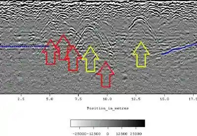
Ground penetrating radar (GPR) is a non-destructive method that identifies subsurface features, without drilling, probing, or digging. The GPR transmitter and antenna emit high-frequency pulses of radio waves into the ground. These pulses have a specific depth penetration rate that is dependent on the dielectric properties of the soil. The transmitted energy is reflected from buried objects or distinct contacts between different earth materials. The antenna then receives the reflected waves and the resulting soil profile is displayed as bands by the digital control unit.
Our training and experience enables us to interpret this data to identify unmarked burials and sub-surface anomalies.
Our ground penetrating radar services can detect disturbed soil caused by:
- Wooden and/or metal caskets
- Voids in the earth with little to no surviving skeletal remains
- Ceremonial burial objects
- Historical objects
- Vaults
- Improperly positioned graves
- Unmarked graves
- Underground utilities
- Etc.

Ground penetrating radar services help with cemetery exploration and grave locating that provides critical information for creating an accurate burial plot map and planning for the cemetery’s future. Preserve history and improve your recordkeeping with careful marking of the unidentified graves in your cemetery.
Proper cemetery records are needed to support people in search of graves to access information and know the exact layout of the burial plots. We integrate the data collected during ground penetrating radar scans into an innovative mapping system to create burial plot maps built on the Esri ArcGIS platform resulting in cemetery plot maps with detailed information that includes the location of unmarked burials.
ViaVista Mapping provides you with a visually appealing cemetery plot map that is known for its precision and quality. The dynamic, searchable burial plot map can be accessed on any connected device or computer through a weblink which greatly improves stakeholder engagement.
How GPR will help you:
Our ground penetrating radar service is a safe and non-invasive way to collect significant data, is the industry standard method for achieving a better understanding of your cemetery, and generates critical information for development of an accurate cemetery plot map.